Until the early 1900s, Yeouido was farming land, [oh really?] but in 1916 during Japan's colonial rule of Korea (1910-1945), the Japanese army built an airstrip there.There's some interesting information there (even if Yeouido was not used as farmland), but this is not entirely correct:
In May 1920, two Italian airmen making a cross-Eurasian flight arrived at the airfield before heading for Tokyo, and were greeted by tens of thousands of Koreans in a welcoming ceremony to see the new means of transportation. Two years later, Korea's first pilot Ahn Chang-nam who studied in Japan flew from Japan to Korea and was met with cheers from Koreans at the airfield.
In April 1929, the airstrip was expanded and was upgraded to an official airport as part of Japan's plan to make Yeouido a stopover for flights between Japan and Manchuria. As an official airport, Yeouido was equipped with basic facilities, including staff offices, telephones, anemoscope, anemometer and a 231-square-meter terminal. The official opening ceremony was held on Sept. 24 that year, the same day as another airport was opened in Ulsan in the southeast of the peninsula. In addition the Japanese colonial authorities built airports in Daegu, Pyongyang, Sineuiju, Cheongjin and Hamheung.
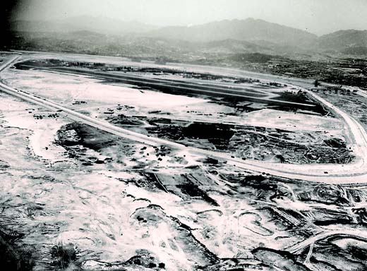
The airport was turned into a plaza where mass gatherings were held, and became a bicycle park at weekends. In 1999, the asphalt was removed, grass was planted and the site was renamed Yeouido Park.I'm assuming, with the reference to asphalt, "airport" above means "runway". If that's the case, it might be worth looking at some photos of the runway before 1971. Here's a shot of it in 1952, when it was used as an airport during the Korean War (more photos by this photographer of Yeouido, Seoul and Gimpo Airport during the Korean War can be found here).

Here are two shots taken in 1968, when the levee was built around the island to prepare it for development. The first looks west.

This one looks southeast.
If these aren't clear enough, here's a map from either the colonial era or in the years after independence showing the location of the runway.
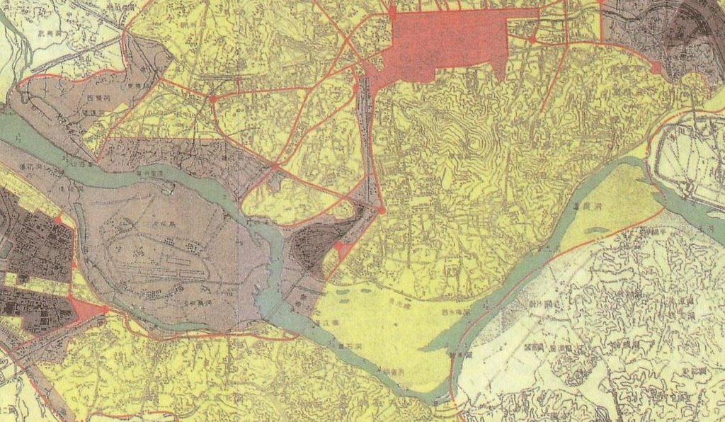
Yeouido Park runs almost perpendicular to it, so I think we can be pretty sure it was never the runway.
2 comments:
If the old map is correct, then the runways would have been roughly where the red line is on this map:
http://i.imgur.com/JzMwtUE.jpg.
I could see Youido Square being a good place for an airport if it were at the bottom of the park near the head of the runway, but there seems to be a building on the old map next to the runways where Youido Subway Station is today.
Actually, the line you drew on the map should be shifted a bit north to account for the fact that the Yeouido of today is smaller, and the river wider, than back then (look at the narrow width of the river on the old map). And I was partly right and partly wrong (I should have gone back and corrected things) - the runway for the airport that existed until 1968 or so was in the location as on the old map, but when Yeouido was developed they build a new 'runway' which was actually, a large asphalt expanse where small planes, perhaps, could land. One reason was to evacuate the National Assembly (or so I read), but the other was to have a large space for the government to hold mass anti-communist rallies (like a million-person one in May 1975), display military vehicles, etc. It was available for private use too (Billy Graham held revival meetings there), but the fact it was named '5.16 Plaza' (after the date of Park Chung-hee's 1961 military coup) highlights its intended function from the state's point of view. By 1999 it had been turned into the park it is today.
Post a Comment